
Great Zimbabwe and the Roads to the Indian Ocean
How the builders, farmers, and metalworkers of Great Zimbabwe sustained a stone city connected to the Indian Ocean, and how archaeology is recovering its changing history.
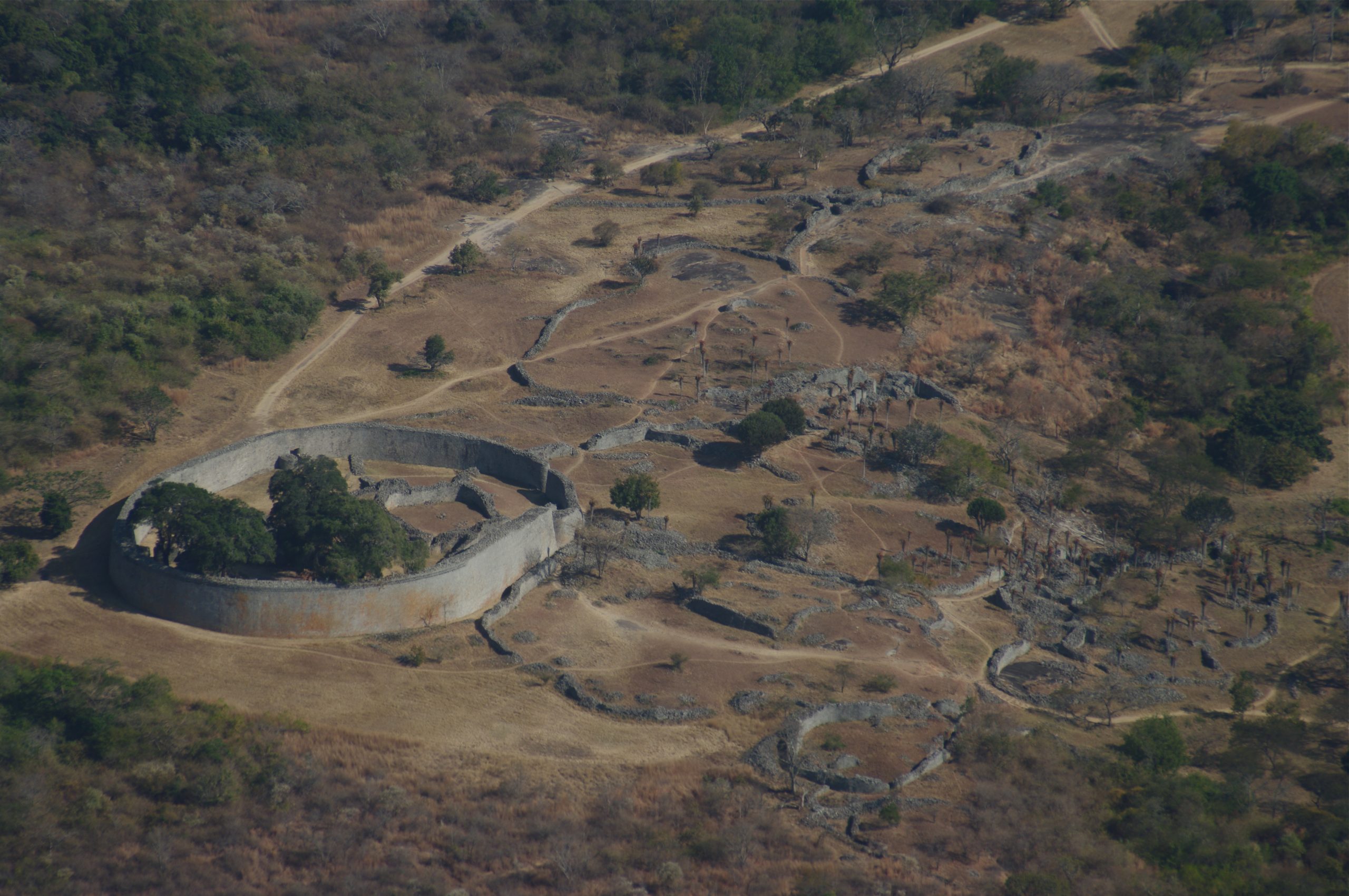
The outer wall of the Great Enclosure rises, at its highest, about eleven metres. Its circuit runs for roughly 252 metres, enclosing smaller walls, the remains of houses, and a solid conical tower whose precise purpose still escapes agreement. Beyond it lie other enclosures; above them, on a granite hill, another concentration of buildings holds its place among the boulders. A city once occupied this landscape in what is now southeastern Zimbabwe. Its stonework has outlasted the greater part of its homes.
Great Zimbabwe grew into a political and economic centre whose connections reached the Indian Ocean. Its inhabitants cultivated crops, tended animals, worked metals, and fashioned objects for use and display. Eight surviving soapstone birds, several combining human and avian features, give a more intimate measure of its artistry than the walls. They have been interpreted as emblems of religious and royal power, although their original meanings cannot be recovered with certainty. The city left neither an easily readable archive nor a complete account of its rulers. Its history must be assembled from the unequal survival of buildings, objects, and the ground beneath them. Museum overview.

Building with the hill
The builders, ancestors of the Shona, worked with the grain of their country. Local granite split naturally into slabs that could be reduced to portable blocks. These were laid without mortar, one course upon another, the face of a wall drawing inward as it rose. Broad foundations carried the weight; the taper helped it stand. In the earlier masonry, irregular stones and existing boulders were fitted together. Later work achieved closely spaced courses and long, controlled curves.
This technique required knowledge accumulated through practice. A stone had to be selected, moved, placed, and balanced against those already laid. The finished surface concealed that sequence of decisions. Across generations, builders refined it until a wall could bend through the landscape with an assurance quite different from a line of rough piled rock.
The great surviving walls were enclosures rather than the load-bearing sides of stone houses. Nor does their mass establish that they were primarily fortifications. Their relation to residence, prestige, and authority matters more than a modern visitor’s first impression of defensive strength. Most of the settlement’s daily life extended beyond the monumental masonry that now commands attention. Architectural evidence.
There was no single moment when this city appeared fully formed. A study combining radiocarbon measurements, surviving archaeological layers, and datable imports places the beginning of substantial stone-wall construction around the late twelfth or early thirteenth century, with its greatest development in the fourteenth and fifteenth. Occupation began earlier and continued after the principal building phase, into at least the sixteenth century and probably the seventeenth.
That longer sequence changes the surrounding history. Older accounts sometimes passed political importance from Mapungubwe to Great Zimbabwe as if one capital had closed and another had opened. The dates indicate overlap. Southern Africa contained interacting centres whose growth cannot be reduced to an orderly procession of successors.
They also change how the ruins should be read. An enclosure beside another enclosure need not have held a contemporary neighbour. The stone city visible today brings together portions of a much longer urban life. The archaeological problem is to recover which parts belonged together. Chronological study.
The work that sustained a capital
The capacity to maintain such a place began close to home. Food, livestock, land, and household work supported a political economy that cannot be explained simply by the arrival of foreign luxuries. Shadreck Chirikure’s reassessment emphasizes seasonal production and circulation within families and communities, alongside the powers of rulers to claim resources. Authority and livelihood met in many places, rather than passing through one perfectly controlled royal storehouse.
This leaves room for a city of active households. Production could take place within a ruler’s influence, outside it, or through arrangements that crossed that boundary. Beliefs connecting land, ancestors, and divine authority helped establish claims over territory and its yield; those claims did not erase the interests or initiative of the people doing the work.
The distinction matters when following wealth toward the coast. Gold could leave the plateau only because someone obtained and processed it. Communities also had to reproduce the ordinary conditions of life while that exchange continued. Foreign trade enlarged the field in which they acted, but the labour sustaining the city retained its own local rhythms, obligations, and uses. Political-economy study.
Water was one of those conditions. In a landscape with pronounced seasonal variation, rain could be abundant at one time and insufficient at another. Researchers have reconsidered depressions around Great Zimbabwe long described as dhaka pits, places from which earth was obtained for construction. Survey, excavation, and analysis of the terrain suggest that some also collected and stored water.
Their position matters. They lay where surface runoff could gather, while groundwater seepage could contribute to the supply. A quarry scar might acquire a second life as a reservoir. Maintaining such spaces would help connect a season of rainfall with the needs of people and animals through drier months.
This is a developing interpretation, not a complete hydraulic plan recovered intact. The investigators explicitly identify precise dating of construction and use as unfinished work. It would be premature to assign every basin to the city’s political height, or to give the whole system a capacity with unwarranted confidence. Even with those limits, the evidence draws attention beyond the famous walls to the less conspicuous shaping of the land that made continued occupation possible. Water-management research.
Gold made for more than export
The gold entered fire in vessels small enough to belong to domestic working spaces. Recent analysis of crucibles, reused potsherds, and other remains has traced its processing across different parts of Great Zimbabwe, inside and outside the stone enclosures. The distribution points toward production by many hands, rather than a single secluded workshop through which all precious metal necessarily passed.
Craftspeople adapted ceramic containers to the demands of heating and handling metal. Finished gold could be hammered into thin sheets or formed into beads and ornaments. Perforated strips suggest that some sheet metal was fastened to wooden features inside buildings. The material that later histories so readily send toward the ocean also had a life at home, adorning people and architectural spaces.
Much evidence was lost when prospectors and antiquarians removed precious objects without recording their settings adequately. The surviving scraps and technical ceramics are consequently important: the waste of production can disclose work that a detached treasure cannot. The modern study’s central finding is that participation in wider exchange rested on local choices, skills, and consumption. Great Zimbabwe’s gold was worked within a society before it circulated beyond it. Gold-working study.
Other materials travelled in the opposite direction. Glass beads reached southern Africa through long-distance exchange centuries before Europeans established themselves on the coast. Their small size belies their historical value. Shape and colour can be compared, while chemical composition can distinguish recipes and help identify broad regions of manufacture.
Analysis of southern African bead series shows changing supplies through time, including glasses associated with Iran and South Asia. Such results are more informative than the convenient label “foreign bead.” They indicate that the connections feeding inland demand were neither unchanging nor confined to one source. Different glasses, workshops, and trading relationships left different material traces.
A bead found at Great Zimbabwe does not record a single uninterrupted journey by one merchant. It may have passed through several hands, been valued in different ways, and remained in use before entering the ground. Archaeology establishes connections more securely than it establishes every stage of an itinerary. The survival of glass also gives it an advantage over cloth and other perishable goods. What can be counted today is only part of what once moved. Glass-bead analysis.
On the East African coast, that wider traffic passed through prosperous Swahili towns. Kilwa Kisiwani and nearby Songo Mnara linked the movement of gold and ivory from southern Africa’s interior with routes across the Indian Ocean. Goods arriving through those maritime connections included glazed ceramics, textiles, perfumes, and silver. The inland stone city belonged to a commercial geography extending far beyond any view obtainable from its hill.
Kilwa’s buildings expressed a different local history in different materials. Earthen and coral-stone structures, religious life, and maritime commerce formed an urban society of the coast. Songo Mnara expanded beside it in the later medieval centuries. Neither place was simply an empty platform on which distant traders met; both had inhabitants and institutions whose choices helped sustain exchange.
Seen through these connections, the distance between the plateau and the ocean becomes a chain of relationships. Inland producers, carriers, coastal communities, and overseas traders participated without sharing a single government. The reach of the network should not be mistaken for the territorial reach of Great Zimbabwe’s rulers. Commercial connections could carry an object much farther than political commands could travel. Coastal context.
A city changing over time
How many people did this system support at Great Zimbabwe itself? The familiar answer of about 20,000 is an estimate, not a count preserved from the city. A 2017 study challenged it by combining settlement chronology with household and demographic modelling. Its authors argued for substantially lower numbers and warned against treating all surviving residential areas as simultaneously occupied.
The difficulty is fundamental. A settlement accumulated over centuries can look much more populous if every house foundation is assigned to the same year. Estimates also depend on how many people are placed in a dwelling, how children are counted, and how much of the surrounding land is treated as residential. Each assumption changes the result.
A lower estimate would not make the walls smaller, the craftsmanship less exacting, or the exchange network less extensive. It would give those achievements a different social scale. For now, the evidence supports caution rather than a replacement number offered with false finality. The disagreement is useful because it obliges any reconstruction to explain how its population fits the buildings’ dates and the wider economy. Population study.
The second struggle over the city
When colonial rule expanded across the region in the late nineteenth century, the authorship of the walls became a political issue. After the British South Africa Company’s occupation in 1890, settlers could make the monument serve their own claims by attributing it to an ancient foreign civilization. Peter Garlake showed how useful that imagined precedent was: earlier successful outsiders would make the new conquest appear a restoration of an old pattern.
Cecil Rhodes recognized this value. Richard Hall, an advocate of remote Biblical origins, was placed in charge of the ruins and promoted those explanations to visitors. The argument did more than assign an incorrect date. It separated the visible achievement from the African societies whose history could explain it.
The masonry was made to testify in a case it had never been built to answer. Its scale became evidence against local authorship only because a racial assumption had been introduced beforehand. Archaeology had to recover both the site’s history and the conditions under which that history had been distorted. Meanwhile, interventions at the ruins damaged the very deposits from which a more reliable account might be reconstructed. History of colonial interpretation.
There was evidence against the foreign-origin theories well before they lost their political usefulness. David Randall-MacIver’s investigations in 1905 supported African authorship. Gertrude Caton-Thompson’s work in 1929 reached the same conclusion through the plan, building methods, and material contents of the sites she examined. A contemporary report in Nature described her findings as confirmation of the result reached twenty-four years earlier.
The significance lay in the convergence of ordinary evidence. Buildings could be examined with their associated objects; objects could be placed within sequences of occupation. No vanished overseas population was required to account for the assemblage. The argument was not that southern Africa had lived without contact. It was that imported goods and indigenous construction were entirely compatible. Trade explained the presence of distant products without transferring authorship of the city to the people who made those products. Contemporary report, 1929.
What the walls still hold
Great Zimbabwe’s political importance diminished, while other centres, including Khami, became more influential. Explanations have invoked environmental pressure, provisioning difficulties, and changes in the regional economy. The older picture of a capital abandoned at one stroke around 1450 sits uneasily beside the longer occupation established by later research. Political decline, movement between neighbourhoods, and complete desertion are different events; they need not have happened together.
The site also retained religious importance. UNESCO’s account recognizes its continued use by local communities for spiritual purposes, a continuity easily obscured when the place is presented only as an archaeological ruin. The name of the modern country and the bird on its national flag brought the monument into another public history, but sacred relationships with the landscape cannot be confined to state symbolism.
The walls now stand in the company of less immediately legible remains: household floors, working debris, discarded beads, and altered ground. Together they preserve the outline of a society that built, traded, adapted, and dispersed across many generations. The city that survives in stone was made possible by work whose traces are smaller and whose makers have largely lost their names. UNESCO site record.
Elsewhere on Histovia, How Achaemenid Persia Governed Distance examines the organization of a different imperial landscape. Adwa 1896 and the Making of Ethiopia’s Victory follows another African society through the age of European expansion.
Sources and further reading
- Tawanda Mukwende, Great Zimbabwe, Metropolitan Museum of Art (2025)
- Metropolitan Museum of Art, Great Zimbabwe (11th–15th Century) (2001)
- Shadreck Chirikure and colleagues, A Bayesian chronology for Great Zimbabwe, Antiquity 87 (2013)
- Shadreck Chirikure, New Perspectives on the Political Economy of Great Zimbabwe, Journal of Archaeological Research 28 (2020)
- Innocent Pikirayi and colleagues, Climate-smart harvesting and storing of water, Anthropocene 40 (2022)
- Shadreck Chirikure and colleagues, Archaeological science, globalisation, and local agency: gold in Great Zimbabwe (2023)
- Peter Robertshaw and colleagues, Southern African glass beads: chemistry, glass sources and patterns of trade, Journal of Archaeological Science 37 (2010)
- Metropolitan Museum of Art and World Monuments Fund, Historic Towns of Kilwa Kisiwani and Songo Mnara (2025)
- Shadreck Chirikure and colleagues, What was the population of Great Zimbabwe (CE1000–1800)?, PLOS ONE (2017)
- Peter S. Garlake, Prehistory and Ideology in Zimbabwe, Africa (1982)
- Zimbabwe, Nature 124 (19 October 1929), contemporary report on Caton-Thompson’s findings
- UNESCO World Heritage Centre, Great Zimbabwe National Monument