Science, Invention & Exploration
John Snow’s Cholera Map: What Broad Street Proved—and What It Did Not
The famous map was part of a larger investigation. Household interviews, a sceptical curate and a comparison of water companies reveal an achievement more demanding than the legend of a single pump handle.
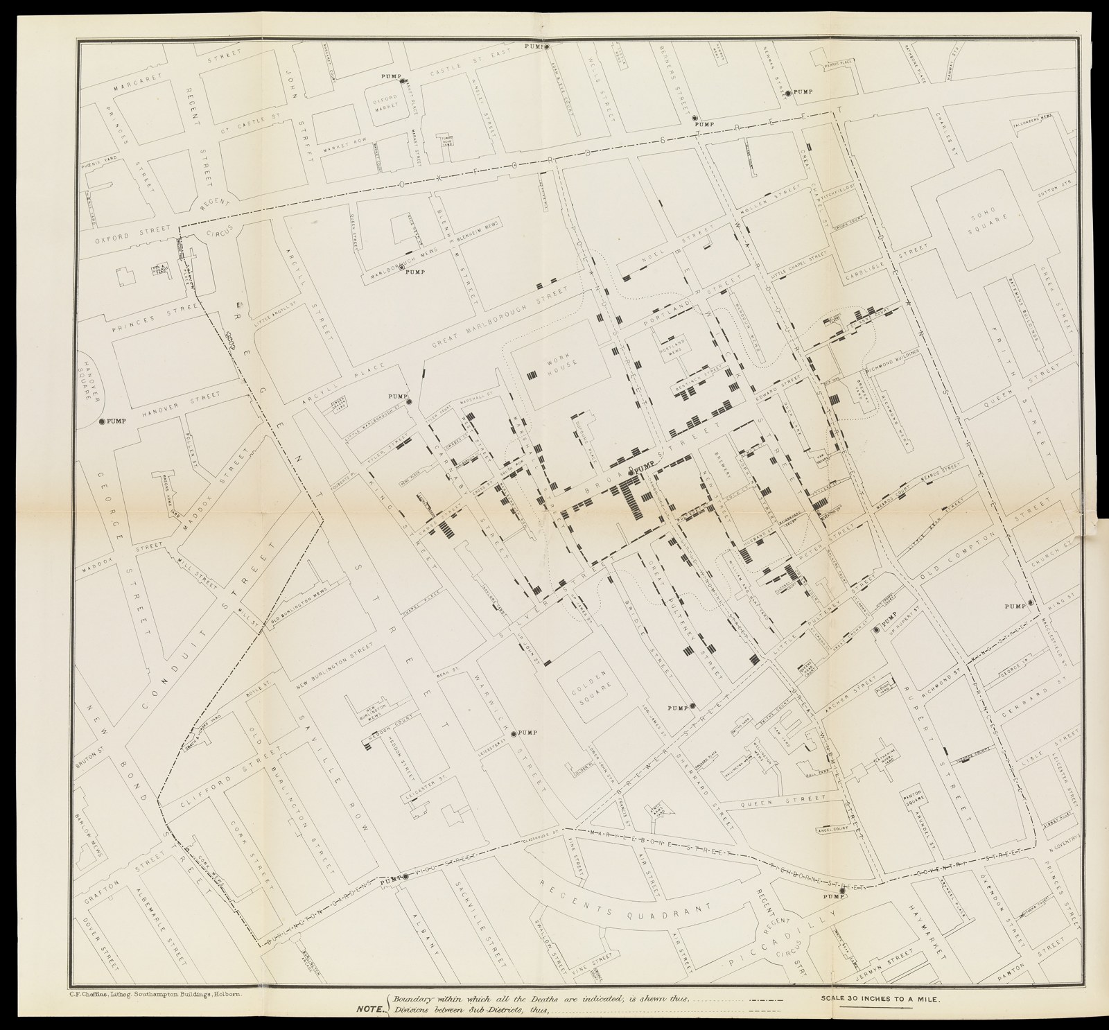
The striking feature of John Snow’s cholera map is not only its crowd of black marks. It is also the space around the Poland Street workhouse, a large institution within the devastated neighbourhood. In Snow’s account, five of its 535 inmates died of cholera, while surrounding streets suffered heavily. The workhouse had its own well and another water supply. Its residents did not ordinarily depend on the public pump in Broad Street.
That contrast mattered more than a simple dot at the centre of a cluster. The question was not merely where people died, but what the people who died—and those who remained well—had consumed. A map could display part of the answer. Interviews, institutional records and comparisons had to supply the rest.
The familiar story compresses this work into an inspired doctor, a map and a removed pump handle. It captures a real achievement, but rearranges its chronology and exaggerates the certainty of a single intervention. Broad Street is more instructive when restored to its crowded setting: competing explanations, incomplete records, a parish inquiry and another investigator who initially doubted Snow.
A theory before the outbreak
Snow did not begin the investigation without an explanation in mind. In the first edition of On the Mode of Communication of Cholera, published in 1849, he had argued that the disease could spread through material from an infected person entering another person’s digestive tract. Contaminated drinking water offered a means of carrying that material to many people at once.
His reasoning was not yet the laboratory demonstration of a specific bacterium. It connected the disease’s intestinal effects with patterns of transmission. That distinction matters: convincing evidence about a route of infection can precede identification of the agent travelling along it.
Other physicians and sanitary reformers offered explanations involving polluted air, local environmental conditions or combinations of influences. These were not simply expressions of indifference to evidence. As the Science Museum’s account of Victorian cholera explains, the relationship between dirt, overcrowding and disease gave competing sanitary theories considerable plausibility. Removing filth could help even when the explanation for its danger was mistaken.
Snow’s hypothesis gave him a particular question to ask when an exceptionally violent outbreak developed around Broad Street at the end of August 1854. It also created a responsibility: he needed to test whether water consumption explained the evidence better than proximity alone. A prior theory could direct a useful investigation, but it was not itself proof.
Following water rather than simply counting houses
In his expanded book of 1855, Snow described obtaining registered deaths and visiting the affected area. He investigated people who had died near other pumps, asking whether they nevertheless drank Broad Street water. Its reputation for agreeable taste could carry its influence beyond the shortest walking route.
The workhouse provided one important contrast. Snow separated its resident deaths from deaths among sick people admitted from outside: the latter would not measure the risk faced by people already living there. He then asked how the institution obtained water. Counting bodies without distinguishing these circumstances would have made the comparison much less useful.
A nearby brewery offered another test. Its proprietor told Snow that more than seventy workmen had escaped severe cholera. They received an allowance of beer, but the premises also had a well and a supply from the New River Company. The relevant point was their reported avoidance of the suspect pump, not a demonstration that beer was a treatment or that every brewery worker had identical habits.
Such inquiries linked geography to behaviour. A person’s home address did not necessarily identify where that person drank: people worked elsewhere, attended school, visited relatives or preferred water carried from another street. Conversely, two neighbours could share the same air while using different supplies. The map acquired explanatory force through these distinctions, not by making them unnecessary.
The map came after the handle
Snow addressed the local Board of Guardians on 7 September. The handle was removed from the Broad Street pump the following day. This was an intervention based on the evidence then available, not the final act after every part of the inquiry had been completed.
The chronology of the celebrated map is different. In their study “Map-making and myth-making in Broad Street,” Howard Brody and colleagues identify Snow’s presentation to the Epidemiological Society on 4 December 1854 as the first documented showing of his cholera map. The familiar printed versions appeared in 1855. That does not establish that he never consulted a map or made an earlier sketch; it does undermine the confident story that the famous published image persuaded the authorities to remove the handle in September.
The image reproduced here belongs to the later parish report, not the first map in Snow’s 1855 book. Its dotted boundary expresses a walking-distance comparison between pumps. It organizes a practical urban landscape of streets and access, rather than merely drawing a circle around a suspected source.
Even the total toll depended on the boundary of the count. The parish committee noted that residents who died in hospitals outside the parish appeared in other districts’ registration figures; non-residents could fall ill after working locally. Its investigators also distinguished the date an illness began from the date a person died. Those were not pedantic corrections. A map of deaths and a timeline of fatal attacks answered different questions, and neither was a complete record of everyone who became sick.
Its marks represent fatal cases associated with addresses, not every infection and not the number of people exposed. A crowded house and a sparsely occupied house cannot automatically be compared by their death totals. Later research reconstructing the population at risk has examined this missing denominator. The original map remains powerful, but its visual clarity should not be confused with a complete statistical explanation.
The curate who checked the story
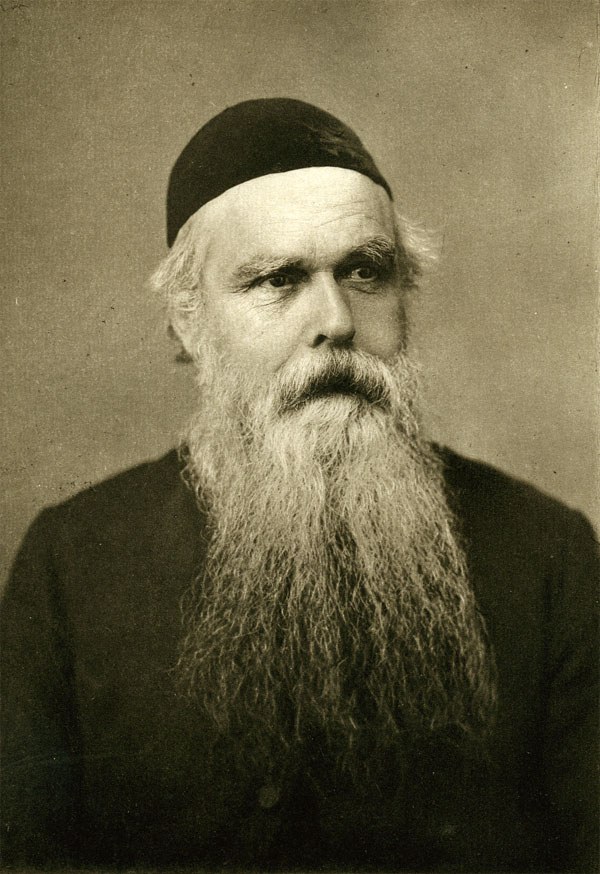
Henry Whitehead, curate of St Luke’s, Berwick Street, knew the district through his pastoral work. He did not enter the investigation as Snow’s obedient assistant. He initially resisted the pump explanation, and his local knowledge became especially valuable because it was used to question rather than simply repeat the theory.
In his report for the parish inquiry, Whitehead described the difficulty of locating people after the catastrophe. Families had moved, survivors were dispersed, and recollections required checking. He returned to some people four or five times. Crucially, he sought information about those who had remained healthy as well as those who had become ill.
His account distinguished what he regarded as certain from what remained probable or unresolved. That discipline is easy to lose in retrospective storytelling. A household interview could establish that someone usually fetched pump water without proving the exact contents of every drink. A person’s survival did not by itself show that the water was harmless, just as residence beside the pump did not establish consumption.
Whitehead’s independent inquiries strengthened the case against the water. They also made the explanation more social: evidence depended on neighbours’ memories, knowledge of families and repeated conversations. The information represented by tidy marks on a printed sheet had been assembled through work that the map could not display.
What lay beneath Broad Street
The investigation continued long after the immediate crisis. The parish Cholera Inquiry Committee’s report recorded an organized effort involving doctors, clergy, local officials and household visits. Initial written questionnaires proved disappointing; direct visits yielded more. The report acknowledged departures, imperfect memories and other obstacles rather than presenting its returns as complete.
Whitehead drew attention to an infant at 40 Broad Street who had died on 2 September after diarrhoea. Washing water from the child’s soiled linen had been disposed of through the house’s drainage arrangements. Subsequent inspection found defective masonry and a plausible connection between contaminated material near the cesspool and the pump well.
This supplied a possible physical route where Snow had initially lacked one. Yet the child should not be converted into an unquestionably identified “patient zero.” As S. P. W. Chave’s study of Whitehead documents, the attending doctor later described the infant’s illness as acute diarrhoea rather than cholera. The diagnosis and sequence cannot be established with modern certainty from the surviving evidence.
Nor does the episode justify making one mother responsible for a neighbourhood’s deaths. The historically significant vulnerability was an arrangement in which human waste could reach a water source used by many households. The inquiry shifted attention from an apparently ordinary pump to the unseen infrastructure beneath it.
The larger experiment south of the Thames
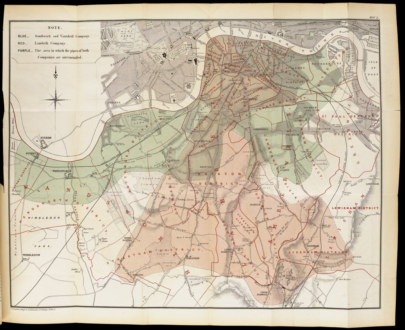
Broad Street was not Snow’s only, or statistically largest, investigation. South of the Thames, customers of the Lambeth and Southwark and Vauxhall water companies lived intermingled in the same districts. Lambeth had moved its river intake upstream in 1852; its rival continued drawing from a more polluted reach. This created a comparison that was not confined to a single neighbourhood well.
Snow’s 1855 discussion of the two companies emphasized how closely their customers could share surrounding conditions. His task was to identify the water supply of households in which cholera deaths occurred and compare mortality against the scale of each company’s service. The coloured map showed overlapping supply areas; it did not eliminate the need to establish individual connections.
In one table for the first seven weeks of the 1854 epidemic, he reported 315 cholera deaths per 10,000 houses supplied by Southwark and Vauxhall, against 37 per 10,000 supplied by Lambeth. The denominator is houses, not inhabitants. The figures belong to that defined comparison, not to the whole epidemic or a universal individual risk.
This was a natural experiment, not a randomized trial. Connections had not been allocated by investigators, and identifying supplies and appropriate denominators required laborious checking. Nevertheless, the contrast was difficult to explain solely by the air of the neighbourhood. A 2015 re-examination by Samantha Hajna, David Buckeridge and James Hanley stresses the value of Snow’s detailed South London data, some of which disappeared from a widely used twentieth-century reprint.
What removing a handle can—and cannot—prove
The Soho outbreak was already declining before 8 September. Snow himself recognized the problem. His reconstructed sequence of attacks showed that the worst phase preceded the intervention, while the departure of residents had also altered the population remaining in the district. He could not determine whether the water still possessed its earlier dangerous character when access was stopped.
Consequently, falling deaths after the handle’s removal do not provide a clean before-and-after demonstration that the intervention ended the outbreak. But the opposite claim—that removing it was necessarily useless—also goes beyond the evidence. Preventing further consumption of a plausibly contaminated supply could be a reasonable precaution without a measurable estimate of exactly how many deaths it prevented.
This is the difference between explaining a transmission route, deciding whether to act and measuring an action’s effect. The three questions are related, but they are not interchangeable. Snow’s own qualifications make him a more interesting investigator than the flawless hero who supposedly settled all three at a glance.
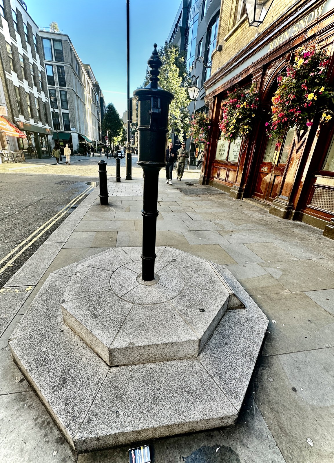
Today the memorial pump in Broadwick Street gives the story a memorable physical object. It is a replica, returned to the historic location in 2018, not the surviving apparatus of 1854. Its absent handle commemorates a decision. The fuller achievement lay in connecting that decision to accumulated evidence: records and conversations, exceptions and comparisons, a theory tested against everyday habits, and conclusions that remained open to correction.