
Science, Invention & Exploration
How Hōkūleʻa Found Tahiti Without Instruments
The 1976 Hōkūleʻa voyage joined living Micronesian navigation with a Hawaiian cultural renewal. What it proved is more precise, and richer, than a simple voyage of rediscovery.
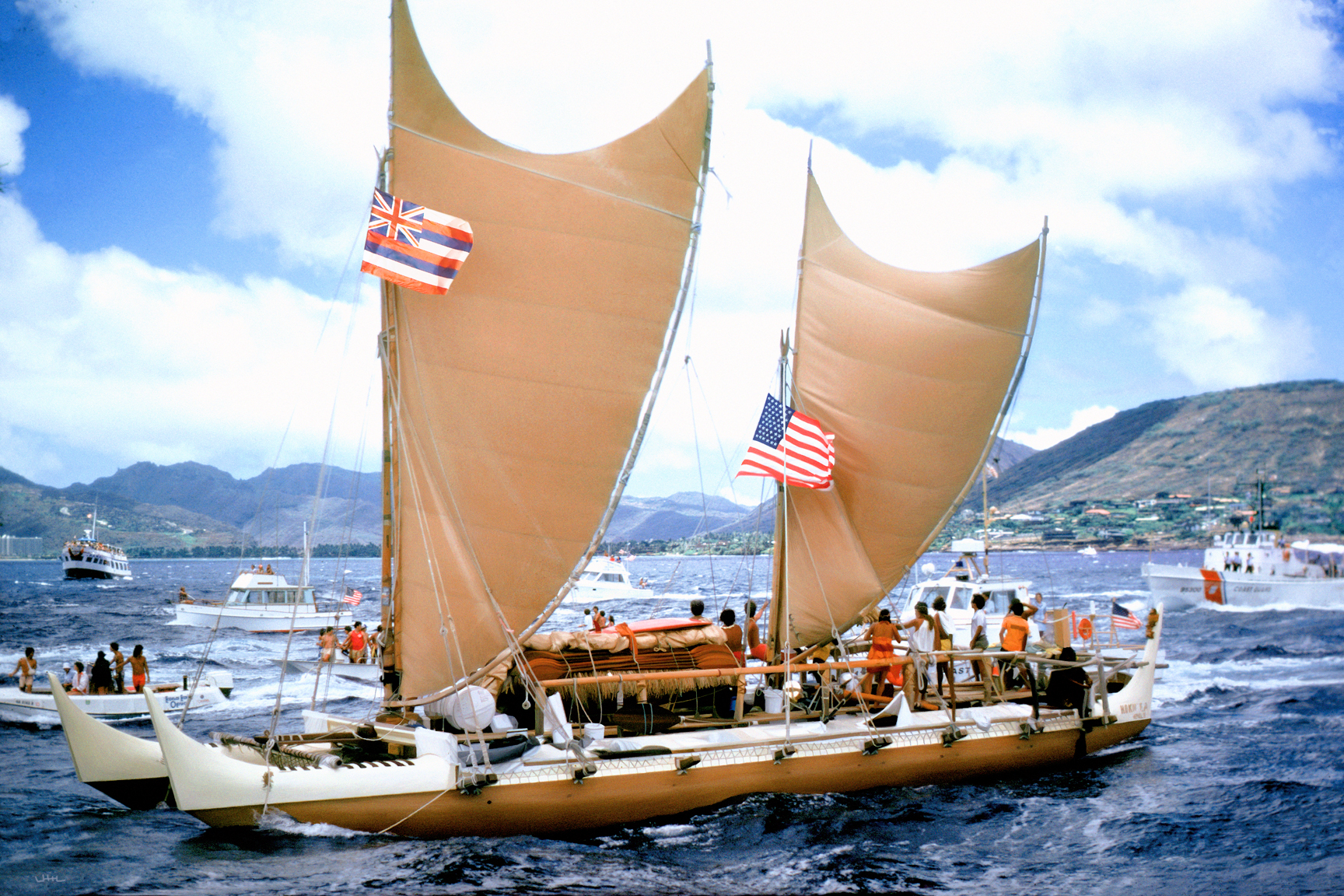
On 1 June 1976, after a month at sea, the crew of Hōkūleʻa reached Mataiva, a low coral atoll in the Tuamotu Islands. Three days later, the double-hulled canoe entered Papeʻete Harbor in Tahiti, where thousands of people gathered to welcome it. The voyage had begun at Honolua Bay, Maui, on 1 May. Its navigator, Mau Piailug, had guided the canoe without the instruments normally associated with an ocean crossing. [1]
The arrival was a practical answer to a historical question. Pacific voyagers could deliberately cross enormous distances and find land. But understanding what the voyage demonstrated requires looking carefully at both halves of its achievement: knowledge preserved through living traditions, and knowledge rebuilt through a modern project of cultural recovery.

An ocean crossed before written charts
The settlement of the Pacific was not a single journey by a single people. Islands and archipelagos were reached in different periods, and their navigators developed related but distinct traditions. Evidence for those movements comes from archaeology, language, oral histories, and other fields. A successful modern canoe voyage can test a vessel’s capabilities. It cannot, by itself, date an ancient settlement or identify the exact route used by its founders.
Chronology has also changed as evidence improved. A major radiocarbon reassessment published in 2011 placed the initial settlement of the Society Islands around 1025–1120 CE and the dispersal to many more distant East Polynesian islands mainly in the late twelfth and thirteenth centuries. Its model placed Hawaiian settlement in the thirteenth century. These are research estimates, not entries in a surviving sailing log; they make the once-familiar claim that Hawaiʻi was settled around 400 CE unsuitable as an unqualified fact. [2]
Building a question large enough to sail
Artist and historian Herb Kawainui Kāne approached the problem through design. What would happen if a full-sized canoe incorporating widely documented Polynesian functional features were actually taken to sea? It could provide evidence about sailing performance while making a neglected inheritance tangible. Kāne recalled seeking support with drawings and a painting; volunteers contributed labor, skill, and money. Hōkūleʻa was launched in 1975. [3]
The canoe was an experimental reconstruction, not an ancient object returned intact to use. Its design drew on historical evidence, and its crews had to learn how to handle the vessel through trials. That distinction strengthens the experiment. Researchers could investigate how a double canoe sailed rather than merely assert that old accounts of voyaging must be true or false.
Kāne also understood that an object could do work beyond the scientific question. Building and sailing a canoe brought people into a shared undertaking. It made historical knowledge something that required hands, materials, training, and repeated collective decisions.
The navigator came from Satawal
The 1976 voyage depended on Mau Piailug, a master navigator from Satawal in Micronesia. He was not a Hawaiian navigator preserving an unbroken local school of ancient Hawaiian practice. The Polynesian Voyaging Society sought his help because it could not find someone within its own Polynesian cultural setting able to undertake the planned crossing using inherited non-instrument navigation. [4]
Calling everything he taught simply “ancient Polynesian navigation” erases that exchange. Mau brought a living Micronesian tradition and the experience of a working navigator. Hawaiian learners developed their own renewed practice through his teaching, observation, study, and time at sea. Continuity and innovation were both present.
It also matters to distinguish navigation from command of the whole vessel. Kawika Kapahulehua was Hōkūleʻa’s captain on the outward voyage; Mau held the navigator’s responsibility. The crossing depended on the work of the crew as well as the knowledge of one exceptional individual. [5]
Keeping a position in the mind
A star does not function like a location pin on a phone. In his explanation of wayfinding, Nainoa Thompson stresses the need to remember the journey: direction, speed, elapsed time, and changes of course. Stars rising and setting at recognizable points help establish headings. Sunlight and the sea provide additional clues. The navigator continually compares them rather than waiting for a single perfect observation. [6]
At sunrise and sunset, the sky can help a navigator establish how the swell relates to direction. That relationship remains useful after the sun climbs higher or clouds hide celestial bodies. Thompson describes Mau’s extraordinary ability to recognize wave patterns through the canoe’s motion. This was practiced perception, acquired over years, rather than a mysterious sense detached from observable conditions.
Landfinding required equally careful interpretation. Some seabirds range over the open ocean; others return to land to roost or feed their young. Their behavior can enlarge an island’s detectable presence beyond its visible shoreline. A bird becomes evidence only when the navigator knows what kind of bird it is and what it is doing.
A compass without a needle
The Hawaiian star compass associated with Thompson divides the horizon into thirty-two named houses. It organizes the rising and setting bearings of celestial bodies and helps relate waves and other directional clues to the canoe. It is primarily a mental framework, although diagrams can make it visible for teaching. [7]
This particular Hawaiian framework developed through Thompson’s learning from Mau. It should not be projected backward as a diagram used identically by every ancient Pacific navigator. A teaching system can draw on inherited knowledge while taking a new form in another language and community.
Its value lies in reducing a changing sky and sea to relationships that can be remembered and used. The navigator must still judge which observations are dependable. Clouds can remove a star; a local wind can complicate the surface waves. The framework supports that judgment rather than replacing it.
What the crossing established
Hawaiʻi and Tahiti do not lie on a convenient straight path downwind. In his account, anthropologist and crew member Ben Finney explains that the canoe had to gain enough easting while working against trade winds and westward-moving water. Mau aimed first for the western Tuamotus, where reaching one island would make the remaining passage to Tahiti manageable. Cloud cover and a spell of calms did not prevent the landfall. [5]
The return trip in 1976 used modern navigation after Mau went home. The claim that this first entire round trip was navigated without instruments is therefore misleading. The outward passage demonstrated deliberate non-instrument landfinding; the round trip also supplied evidence about the canoe’s sailing performance.
A voyage became a school
The project did not end at the welcoming beach. In his retrospective on twenty-five years of voyaging, Thompson describes how an experiment intended around a voyage to Tahiti became a stimulus to cultural renewal. The canoe gave communities a working focus for recovering skills, making relationships across islands, and training another generation. [8]
That development included loss. Hōkūleʻa capsized during another attempted voyage in 1978, and crew member Eddie Aikau disappeared after paddling away to seek help. In 1980, Thompson navigated to Tahiti and back, with Mau aboard in support. [4] The enduring evidence of 1976 was thus more than a track across the ocean. It was knowledge that other people could learn, test, and carry on the next departure.
Sources and further reading
- Polynesian Voyaging Society, fiftieth-anniversary account of the 1976 maiden voyage (2026). Departure, Mataiva landfall, and 4 June arrival chronology.
- Janet M. Wilmshurst and colleagues, “High-precision radiocarbon dating shows recent and rapid initial human colonization of East Polynesia,” PNAS 108 (2011), 1815–1820.
- Herb Kawainui Kāne, “Founding the Polynesian Voyaging Society; Building and Naming Hōkūleʻa.” Participant’s account in the PVS archive.
- Polynesian Voyaging Society, “History.” Mau’s teaching, the 1978 loss, and the 1980 voyage.
- Ben Finney, “1976 Hawaiʻi to Tahiti and Back.” Participant’s account; explicitly distinguishes navigation on the outward and return legs.
- Nainoa Thompson, “On Wayfinding.” First-person explanation of observation and landfinding.
- Polynesian Voyaging Society, “The Star Compass.” Thompson’s Hawaiian teaching framework.
- Nainoa Thompson, “Twenty-Five Years of Voyaging, 1975–2000.”