
Civilizations & Empires
The Inca Road and the Runners Who Held an Empire Together
Across the Andes, roads, relay runners, storehouses and knotted records made Inca government possible. Their history reveals the recurring labor behind an imperial network.
A road in the Andes could end at a river that could not be forded. Beyond it lay another stretch of paving, a hillside staircase, a storage settlement and the next inhabited valley. Keeping those pieces connected required more than an initial act of construction. Someone had to replace the bridge, supply the travelers and carry news when a ruler needed to know what was happening far from Cusco.
The Inca state made those recurring tasks part of government. Its Qhapaq Ñan, usually translated as the royal or principal road, joined an enormous variety of local paths into a system that moved people, goods and information across western South America. UNESCO’s description of the network emphasizes both its inherited Andean foundations and its expansion under Inca rule. The roads worked because communities, officials, storekeepers and relay runners worked along them.
An empire built on older paths
The familiar image of an Inca road beginning from nothing with an imperial command obscures a much longer history. Andean peoples had developed routes, settlements and engineering traditions centuries before the Inca expansion. The Smithsonian’s historical timeline places the Inca achievement after the regional worlds of Chavín, Tiwanaku, Wari and Chimú. Imperial planners inherited experience as well as terrain. Incorporating an existing road could be as important as laying a new one.
The expansion conventionally associated with Pachacuti began around 1438. That is a historical reconstruction, not a surviving dated Inca decree. Over the following generations, campaigns and political incorporation brought an immense territory into Tawantinsuyu, the four regions together. The Metropolitan Museum’s Andean chronology follows this rapid transformation from regional power to empire. Roads made those gains more governable, while each new region gave the state more labor and resources with which to extend them.
Four principal directions organized the relationship between Cusco and the suyus. Branches joined valleys, production zones, provincial centers and sacred places. No single modern mileage captures every part with equal certainty. UNESCO describes more than 30,000 kilometers; the Smithsonian’s engineering introduction gives nearly 40,000. Such totals depend on which routes an inventory includes and how the network is defined. Both describe a continental network, not simply the hiking route now commonly called the Inca Trail.
A road shaped to the ground
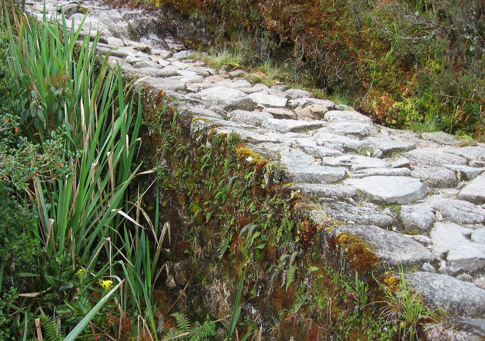
Uniform government did not require identical construction. A broad paved approach near Cusco, an exposed highland passage and a route through coastal desert presented different problems. Builders used available materials and adjusted their work to local conditions. Stone paving helped in heavily used places; retaining works and grading made difficult slopes passable; culverts allowed water to move beneath a route. The Smithsonian’s account of regional engineering makes variation part of the explanation for the network’s success.
The engineering choices also reveal what the road was expected to carry. People traveled on foot, and llama caravans moved loads. A steep stairway was therefore compatible with the transport system in a way it would not have been with a highway designed for wheeled carts. Roads need to be understood through their users. Judging this network against modern traffic would conceal the close fit between its surfaces, its animals and the human labor on which it depended.
Nor was it an unrestricted public highway in the modern sense. The Smithsonian’s discussion of road users identifies royal travelers, armies, delegations, work parties and messengers, and notes that ordinary people needed local permission. Control of movement was part of the system. The same route that connected a valley with distant supplies also helped officials direct labor or bring armed force into it.
The message traveled farther than the runner
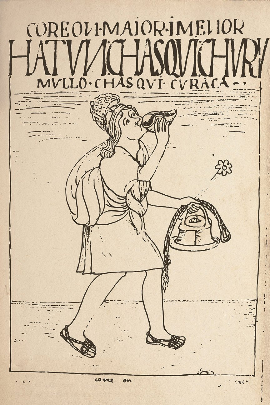
The chasqui, also spelled chaski, supplied the system with speed. His task was a short stage of a much longer journey. A message passed to another trained runner, who carried it onward while the previous runner remained near his assigned station. The enduring achievement lay in that division of effort: government could keep information moving without requiring a single exhausted messenger to cover the whole distance.
The Smithsonian’s guide to official messengers describes oral messages, khipu records and small parcels passing through the relays. Accuracy mattered as much as running ability. Spoken instructions had to survive successive transfers. A cord record could preserve numerical information, but its usefulness still depended on people who knew how to interpret it and on reliable delivery to the intended officials.
Popular accounts sometimes turn reported speeds into precise, universal timetables. That confidence exceeds the evidence. Colonial descriptions differ over the distance between stations, the numbers stationed there and the terminology for roadside buildings. An archaeological and ethnohistorical study of road installations compares these accounts rather than treating every description as a standard rule. Mountain gradients, regional arrangements and the difference between a remembered ideal and daily practice all matter.
Guaman Poma’s famous messenger drawing is valuable for a similar reason. It belongs to an Indigenous author’s early seventeenth-century account of Andean life under colonial rule, looking back on the Inca past. The shell trumpet, clothing and cord record are represented evidence, not a photograph of a fifteenth-century relay. His chronicle asks readers to consider good and bad government. The image should illuminate that historical testimony without becoming proof of every detail of every runner’s equipment.
The buildings that made movement possible
Travelers and soldiers needed food and shelter. The tampu, commonly rendered tambo in Spanish, helped provide both. These installations ranged in scale and setting; their role in a journey should not be confused with the small stations associated with message relays. The Smithsonian’s account of travelers’ lodgings describes accommodation for officials, soldiers and workers, with provisions stored at the site. Mountain buildings could use fieldstone while coastal ones used adobe.
This infrastructure changed the practical reach of a government order. A command to move soldiers had little value if the next stage offered nothing to eat. Food placed along routes allowed forces and officials to draw on supplies without carrying everything from their point of departure. That did not eliminate local burdens. It transferred part of the preparation to the communities whose crops, labor and buildings supported the journey.
Storage was therefore central. The Inca established thousands of colcas, or qollqas, for food and other supplies. The Smithsonian’s storehouse account describes round and rectangular buildings whose construction and placement helped keep contents cool and dry. Maize, potatoes, quinoa, clothing, tools and weapons could all enter these stores. The variety is important: an imperial reserve supported work and military activity as well as subsistence.
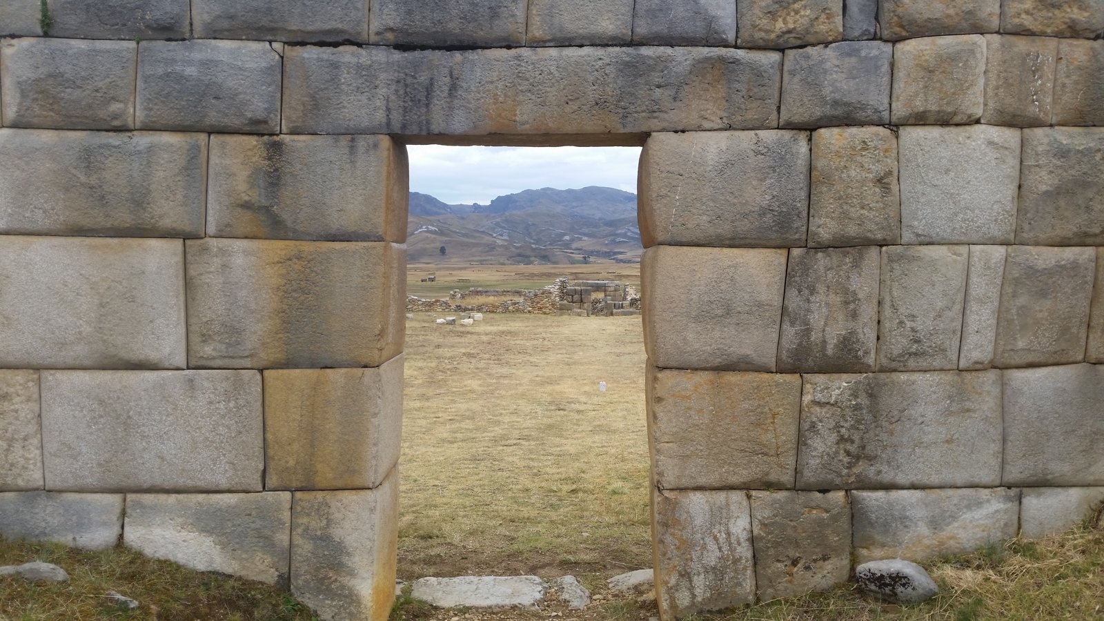
Huánuco Pampa gives that administrative landscape a monumental form. Set high in the Andes on the route between Cusco and Quito, it was one of the major provincial centers. Archaeologist Craig Morris’s study of its spatial organization treats the settlement as evidence for the organization of Inca power. Its architecture makes the road visible as something larger than a strip of ground: movement led into places where people could be assembled and resources managed.
Morris and R. Alan Covey’s research on the central plaza further interprets these planned spaces as settings in which imperial representatives negotiated and reshaped relationships among local groups. Provincial administration involved social encounters and ceremony as well as quantities. A gathering organized by the state could distribute provisions, display hierarchy and bring communities into a relationship with an authority based far away.
Knots people could read
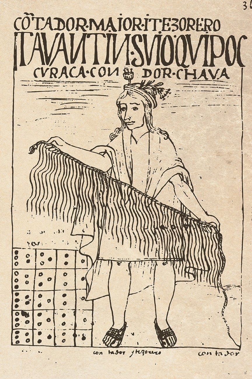
Supplies had to be counted, obligations recorded and information compared. Khipus joined pendant cords, knots and other material distinctions in a system of record keeping. Their numerical capacities are well established, while the full range of meanings carried by surviving examples remains a subject of research. Calling them either mere memory aids or fully deciphered books closes the question too quickly.
The Museo Larco’s account of Inca quipus emphasizes the specialist officials who handled this information, the quipucamayocs. Their presence connects the warehouse to the road. A record might travel, but the knowledge necessary to produce and interpret it belonged to trained people. Imperial communication consequently combined durable objects with spoken explanation and human expertise.
Material wealth also took forms unfamiliar to conquerors who placed exceptional value on precious metal. The Metropolitan Museum’s discussion of an Inca tunic explains the exceptional labor embodied in fine cumbi cloth and its use in imperial rewards and storehouses. Textiles circulated as politically meaningful goods. A road carrying clothing could be carrying a ruler’s recognition of service, a visible marker of status or the products of organized workshops.
Bridges were continuing commitments
At major rivers, the network depended on technologies that could cross a gap without masonry arches. Inca suspension bridges used braided vegetal cables; other settings called for stone crossings or reed structures. The Smithsonian’s river-crossing account describes a range of solutions. The most spectacular bridge was only one element in a practical effort to prevent geography from breaking an administrative route.
Vegetal cables also made deterioration unavoidable. Communities served by bridges were expected to maintain them, and replacement could occur every year or two. In the Smithsonian’s discussion of bridge safety, maintenance is integral to the engineering. A bridge was an obligation renewed over time. Its existence depended on authority being able to mobilize knowledge and labor again, after the original builders had gone.
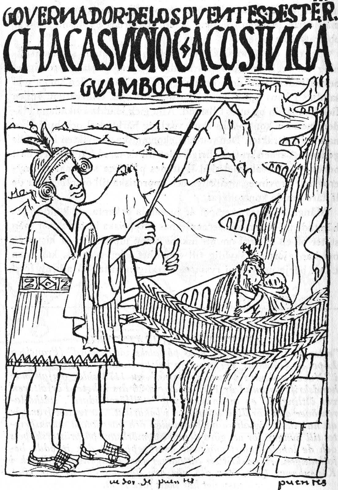
That relationship can still be understood at Q’eswachaka on the Apurímac River. UNESCO’s record of the annual renewal tradition, inscribed in 2013, names four Quechua communities involved in rebuilding the bridge. Families prepare ropes, experienced builders direct the work and ritual accompanies construction. This is living community knowledge. The modern bridge should not be described as the same untouched material surviving from the empire.
The network after conquest
The road’s usefulness did not guarantee the security of the power that had enlarged it. When Spanish forces entered the Inca world in 1532, they encountered a society already disrupted by epidemic disease and dynastic war. Existing routes could serve invading forces as well as imperial administrators. The Smithsonian’s exhibition on the Inca road presents engineering as essential to imperial scale; the history of conquest also shows why infrastructure alone could not preserve political control.
The later road was neither simply abandoned nor preserved whole. Colonial priorities changed where people traveled and what they carried. Some sections deteriorated, while local communities kept using others. The network now recognized across six countries combines archaeological remains with routes and practices that still matter to their custodians. Its long survival is uneven, which makes sweeping claims that it disappeared or remained intact equally misleading.
Looking at the Qhapaq Ñan through its runners brings its largest achievement into focus. A message needed a passable path, a prepared successor, support at the station and someone capable of acting when it arrived. Roads, storage and records belonged to one system of repeated work. That perspective also offers a useful comparison with Great Zimbabwe’s connections to the Indian Ocean: immense historical networks become easier to understand when we ask who kept movement possible, and on whose labor that movement depended.
Sources and further reading
- UNESCO’s description of the network
- historical timeline
- Andean chronology
- engineering introduction
- account of regional engineering
- discussion of road users
- guide to official messengers
- archaeological and ethnohistorical study of road installations
- account of travelers’ lodgings
- storehouse account
- study of its spatial organization
- research on the central plaza
- Museo Larco’s account of Inca quipus
- discussion of an Inca tunic
- river-crossing account
- discussion of bridge safety
- record of the annual renewal tradition
- exhibition on the Inca road